Today's weather: Disruptive rain and flood warnings issued for Limpopo, Mpumalanga and Gauteng
South Africa braces for heavy rainfall and thunderstorms on Monday
Image: Supplied
Monday brings a wet and potentially disruptive day for large parts of South Africa, particularly across the northern and eastern regions.
A slow-moving weather system is driving widespread cloud cover, persistent rainfall and thunderstorms, with the highest impacts expected in Limpopo, Mpumalanga and Gauteng.
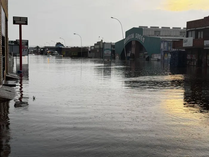
The South African Weather Service (SAWS) has issued an Orange Level 5 warning for disruptive rain affecting Gauteng, Limpopo and Mpumalanga. Rainfall totals of 30 to 60 millimetres are possible in parts of Limpopo, especially the Lowveld and the eastern Limpopo Valley, increasing the risk of flooding.
Recent saturated ground conditions mean even moderate additional rainfall could quickly lead to surface flooding.
Impacts expected today include flooded roads and low-lying settlements, disruptions to traffic as some major routes become waterlogged, and communities that may be temporarily cut off.
Fast-flowing streams and rivers pose a danger to life, and there is an increased risk of damage to vulnerable structures, particularly mud-based or informal housing, as well as possible mudslides and soil erosion in hilly areas.
Parts of the eastern Free State have a 30% chance of rain, mainly in the form of showers and thunderstorms that could become locally heavy. Along the KwaZulu-Natal coast and adjacent interior, rain chances are also around 60%, with storms spreading inland at times.
The central and western interior, including much of the Northern Cape and western Free State, remain mostly dry with little to no chance of rain.
Residents in affected areas are urged to remain weather aware throughout the day, avoid crossing flooded roads or bridges, and allow extra travel time where storms develop.
Conditions are expected to remain unsettled into the evening, especially in the eastern parts of the country.
IOL News