Hey Mzansi, here’s what the weather has in store for your New Year’s Eve

A yellow level four warning has been issued for the OR Tambo and Amathole districts in the Eastern Cape.
Image: FILE
Thunder, heat and fire danger are all set to share the stage as South Africans count down to the New Year.
The South African Weather Service (SAWS) has issued two severe thunderstorm warnings for New Year’s Eve, along with fire danger alerts and a heat advisory, as unsettled weather spreads across large parts of the country.
Senior SAWS forecaster Jacqueline Modika said a yellow level four warning has been issued for the OR Tambo and Amathole districts in the Eastern Cape.
“These storms are expected to be accompanied by heavy downpours, damaging winds, excessive lightning and hail,” said Modika.
“They could lead to localised flooding and damage to infrastructure and settlements.”
A yellow level two warning also covers Gauteng, parts of Limpopo, the Highveld and escarpment of Mpumalanga, the southern parts of the North West, parts of the Free State, and the eastern half of the Eastern Cape.
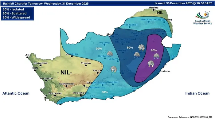
Rain forecast for December 31.
Image: SA Weather Service
“These thunderstorms will also bring heavy rain, damaging winds and a lot of small hail in some areas,” Modika said.
She said hot, dry and windy conditions have triggered a fire danger warning for the Northern Cape, parts of the Free State, and the Beaufort West municipality in the Western Cape.
Residents are urged not to start fires or leave them unattended, as they could spread rapidly, according to Modika.
In addition, an advisory has been issued for the Khâi-Ma Local Municipality in the Northern Cape, for very hot and uncomfortable conditions.
Provincial Outlook
Modika said Gauteng will be partly cloudy and warm, with scattered showers and thundershowers from late afternoon.
Mpumalanga will be cloudy and warm, with scattered to widespread showers, while lowveld areas will see isolated thundershowers.
Limpopo will be cloudy and warm, with isolated afternoon showers, but scattered in the south-east, and very hot in the western bushveld.
The North West will be partly cloudy and warm, with scattered showers and isolated storms in the west.
The Free State will be partly cloudy and warm to hot, with scattered afternoon showers, becoming isolated in the west.
In the Northern Cape, it will be cloudy in the north-west in the morning, otherwise fine and very hot, with a small chance of isolated storms in central and eastern areas.
The Western Cape will have morning fog along the coast, then partly cloudy and warm to hot, with light rain along the south coast.
The western half of the Eastern Cape will start sunny and then turn partly cloudy, with isolated late-afternoon storms, while the eastern half will have scattered to widespread showers.
KwaZulu-Natal will see morning fog in the central and western interior, then partly cloudy and warm to hot, with showers becoming widespread in the west, Modika said.
IOL News